Day trips
Busua, Butre and Dixcove from Takoradi by Car: Beaches, Forts and Car Rental & Hire
Quick answer: To get from Takoradi to Busua, Butre and Dixcove by car, take the N1 west to Agona, then turn south on the regional roads to the coast. The Ghana Highway Authority's map marks these roads through Asane and Boekrom, splitting for Busua and Dixcove. Nobody official publishes a Takoradi–Busua distance or drive time. The Takoradi–Agona stretch is being made into a dual carriageway, and the road from Agona to Dixcove has been in poor condition, so check with your driver or hire firm before you go and plan to be back in daylight.
This guide covers the short drive from Takoradi to the beaches and forts of Busua, Butre and Dixcove: the roads the official maps show, what's happening on them in 2026, the two forts, beach safety and car hire & rental for the trip. If you're coming from further away, our Accra to Takoradi, Cape Coast to Takoradi and Kumasi to Takoradi guides cover the drive to Takoradi itself.
Busua, Butre and Dixcove at a glance
| Question | What we found (checked 1 November 2026) |
|---|---|
| Where | Ahanta West Municipality, Western Region |
| Municipal capital | Agona Nkwanta |
| Official distance from Takoradi | None published |
| Official drive time | None published |
| Main road | N1 west from Takoradi to Agona |
| Roads to the coast | Regional roads R-084 and R-085 |
| Forts | Fort Metal Cross (Dixcove), Fort Batenstein (Butre) |
| Fort opening hours | 9:00am to 4:30pm, per the GMMB |
| Biggest 2026 issues | Dualisation works to Agona; poor Agona–Dixcove road |
Where are Busua, Butre and Dixcove?
All three are on the coast of the Ahanta West Municipality, west of Sekondi-Takoradi. The Ministry of Finance's 2026 budget for the Ahanta West Municipal Assembly says the assembly was set up in 1988 with Agona Nkwanta as its capital and became a municipality in 2018. Busua and Dixcove are two of its six zonal councils.
The same budget lists the area's tourist sites: Busua Beach Resort, the river delta at Pumpunie, the wooded beach near Dixcove, the lighthouse at Cape Three Points (which it calls the southernmost point in Ghana) and "a vast stretch of beautiful sandy beaches". It adds that the municipality is home to four of the eight forts in the Western Region. The Ghana Tourism Authority's Visit Ghana site names Fort Metal Cross at Dixcove and Busua Beach among the region's attractions.
How far is Busua from Takoradi?
There's no official Takoradi–Busua or Takoradi–Dixcove distance. The Ghana Highway Authority's road network table only lists whole trunk roads, such as the N1 from Elubo to Tema, and has no figure for the roads to Busua or Dixcove. We don't use route-planner or blog estimates.
The only lengths we found are for the two parts of the drive. MyJoyOnline and Citi Newsroom reported in September 2026 that the Takoradi–Agona Nkwanta road being dualled is 23 km, and 3News called the Agona Nkwanta–Dixcove road a 12-kilometre stretch in August 2025. Neither figure is official for the whole trip.
How long does it take? We found no official journey time. Allow extra time for roadworks on the N1 and the poor surface on the road down to the coast.
The route from Takoradi on the official map
The GHA's 2020 Western Region trunk road map (linked in the Sources list) shows this route. Place names are spelled as on the map.
- Leave Sekondi-Takoradi west on the N1 through Kwesimintsim, Apowa, Beahun, Bokro, Ewusiejo and Aboadi to Agona, with Agona Nkwanta just beside it.
- At Agona, turn south on the regional road the map marks R-084, through Asane and Boekrom.
- Near Asane and Boekrom the road divides. The map marks roads R-084 and R-085, one reaching Busua and one reaching Dixcove on the coast.
Butre isn't marked on the GHA map, and we found no official description of the road to it. Ask your driver, or contact Butre's Town Tourism Development Committee through the GMMB (see below), before you set off.
Road conditions (checked 1 November 2026)
Takoradi to Agona: dual carriageway nearly finished
The first part of the trip is the N1 from Takoradi to Agona Junction, which is being turned from a single into a dual carriageway. On 16 September 2026, MyJoyOnline reported that the 23 km project includes four major concrete bridges, among them dual-carriageway bridges at Apremdo and Ewusiejoe. The managing director of the contractor, Justmoh Construction, said the remaining work was road protection, guardrails and road markings, and that the road would be handed over by the end of November 2026, ahead of the contract deadline of 19 March 2027. We found no official notice that it had been handed over by 1 November 2026, so expect work crews and lane changes.
Agona Nkwanta to Dixcove: still waiting for repairs
The road from the N1 down to Dixcove has a long history of complaints. In August 2025, 3News reported that the 12 km Agona Nkwanta–Dixcove road was in a "deplorable condition". It's the route to the Nana Hima Dekyi Hospital at Dixcove, which 3News called the only referral health facility in Ahanta West. The Omanhene of Lower Dixcove threatened a strike if the road wasn't built by the end of 2025, and the Municipal Chief Executive said the government had prioritised it.
In June 2026, 3News reported the Western Regional Minister as saying contractors would soon be on Ahanta West's roads, naming the Agona Nkwanta–Dixcove road and the Sankor Junction–Akwadae–Cape Three Points road among the priorities. We found no reputable report that work has started on either road as of 1 November 2026. The 2026 Ahanta West budget rates 60.73% of the municipality's 354 km of roads as poor.
The Busua–Dixcove bridge
In February 2026, the Ahanta West Municipal Assembly commissioned a renovated steel bridge linking Busua and Dixcove, funded from the District Assemblies Common Fund, according to the Ghanaian Chronicle. The paper said the old bridge's deteriorated steel had posed a danger to pedestrians and motorists.
The forts: Fort Metal Cross and Fort Batenstein
Both forts are National Monuments under the Ghana Museums and Monuments Board (GMMB), and both are part of the UNESCO World Heritage property of Ghana's forts and castles, inscribed in 1979. UNESCO lists Fort Metal Cross among the property's 15 forts and Fort Batenstein among the forts partly in ruins.
Fort Metal Cross, Dixcove
The GMMB says the British started building the fort, first called Dixcove Fort, in 1692 on a promontory near the fishing village of Infuma in Dixcove. It passed to the Dutch in 1868 under an 1867 exchange agreement and was renamed "Metalen Kruis" (Metal Cross) after a Dutch gunboat, then went back to the British in 1872. It has been used by the police and the postal service and, according to the GMMB, is currently leased to a private organisation. The GMMB gives its opening hours as 9:00am to 4:30pm. Because of the lease, check access before you go.
Fort Batenstein, Butre
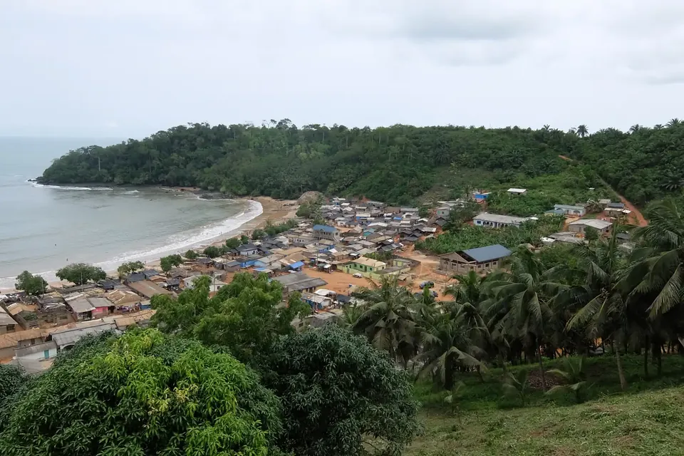
The GMMB says the Dutch built Fort Batenstein in 1656 on the high hill behind Butre village, and the British took it over on 6 April 1872. It was consolidated in 2010–2011 with co-funding from the Italian Ministry of Foreign Affairs and is preserved as a ruin. Butre has a Town Tourism Development Committee that offers guided tours of the fort and the area. Opening hours are 9:00am to 4:30pm. The hero photo at the top of this guide was taken from the fort's hill.
For both forts, the GMMB's Central and Western Regions office is at Cape Coast Castle. We don't quote entrance fees; pay at the site and ask for a receipt.
Busua and the Marine Protected Area
In April 2026, the Ghana News Agency reported that the Vice President declared Ghana's first Marine Protected Area at Busua. It covers about 700 km² of coastal waters in 21 communities in the Greater Cape Three Points enclave. Fishing communities keep access, but the aim is a shift to more sustainable fishing methods. You'll see working fishing canoes on these beaches, so give boats and nets plenty of room.
Beach safety and money
The UK FCDO says swimming is dangerous on the beaches along Ghana's southern coast because of rip tides and undertows, and that there are occasional reports of deaths of adults and children. It also says:
- theft is the main problem at beaches, with isolated incidents of violent crime and sexual assault in tourist areas
- don't visit beaches alone, and take care on public beaches
- ATMs are common in large towns but may not be available in rural areas, so have back-up funds
- avoid road travel outside the main towns after dark, when the risk of accidents and attacks on vehicles is higher
Ask locally where it's safe to swim, keep valuables out of sight in the car, and plan to drive back to Takoradi before dark.
Market days around Agona
The Ahanta West budget says the municipality's main weekly market days are Wednesdays and Fridays, and that Agona Nkwanta Market is its central business area. If you pass through on those days, allow for market traffic.
Car rental & hire for Busua, Butre and Dixcove
Most visitors do this as a day trip or a short stay from Takoradi with a hired car and driver. Compare car hire & rental in Takoradi, and see our Kumasi and Takoradi car hire guide for self-drive, one-way hire and longer trips along the coast. If you're flying in to Takoradi for work, our Takoradi business car hire guide covers airport pickups.
Agree the terms in writing
| Agree in writing | Why it matters |
|---|---|
| Stops (Busua, Butre, Dixcove) | So the driver plans the right roads |
| Day trip or overnight | Driver's room and meals if you stay |
| Waiting time at beaches and forts | Visits can run longer than planned |
| Return time | So you're back in Takoradi before dark |
| Vehicle type | Poor surface on the Agona–Dixcove road |
| Fuel, tolls and parking | So you know what's in the price |
We don't publish prices, because they change often in Ghana. Ask each firm for a dated written quote, and never pay a deposit into a personal account that doesn't match the firm's name.
Frequently asked questions
How far is Busua from Takoradi?
There's no official figure. The Ghana Highway Authority publishes no distance for the roads to Busua or Dixcove. MyJoyOnline and Citi Newsroom give the Takoradi–Agona Nkwanta road being dualled as 23 km, and 3News described the Agona Nkwanta–Dixcove road as 12 km, but neither is an official figure for the whole trip.
How do I get from Takoradi to Busua by car?
Drive west on the N1 to Agona, then turn south on the regional road through Asane and Boekrom. The GHA's Western Region map shows the road dividing there, with branches to Busua and Dixcove.
Is the road to Dixcove in good condition?
Not according to recent reports. 3News called the Agona Nkwanta–Dixcove road deplorable in August 2025, and in June 2026 the Western Regional Minister said contractors would soon move to site. We found no report that work had started by 1 November 2026.
What are the opening hours of Fort Metal Cross and Fort Batenstein?
The Ghana Museums and Monuments Board gives 9:00am to 4:30pm for both. Fort Metal Cross is leased to a private organisation, so check access first. At Butre, the Town Tourism Development Committee offers guided tours of Fort Batenstein.
Is it safe to swim at Busua?
The UK FCDO says swimming is dangerous on beaches along Ghana's southern coast because of rip tides and undertows. Ask locally where it's safe, don't go to the beach alone, and keep valuables secure.
Can I do Busua, Butre and Dixcove as a day trip from Takoradi?
Yes, many visitors do. Agree the stops, waiting time and return time with your driver in writing, and plan to be back in Takoradi before dark, as the FCDO advises against road travel outside the main towns at night.
Book your Busua and Dixcove trip
Compare car hire & rental in Takoradi. Send each firm your date, pickup address, number of passengers and the stops you want, and ask for the price, waiting time and overtime in writing.
Sources
- Ahanta West Municipal Assembly composite budget 2026–2029 (capital Agona Nkwanta; Busua and Dixcove zonal councils; tourist sites; four of the Western Region's eight forts; 354 km of roads, 60.73% poor; market days) (Ministry of Finance)
- Road Network: N1 Elubo–Tema 540 km; no Takoradi–Busua or Takoradi–Dixcove figure (checked 1 November 2026) (Ghana Highway Authority)
- Western Regional Trunk Road Map, 2020 (N1 from Sekondi-Takoradi via Kwesimintsim, Apowa, Ewusiejo and Aboadi to Agona; regional roads R-084 and R-085 via Asane and Boekrom to Busua and Dixcove) (Ghana Highway Authority)
- Takoradi–Agona Nkwanta road to open to traffic by November – Contractor (23 km dual carriageway; bridges at Apremdo and Ewusiejoe; 16 September 2026) (MyJoyOnline)
- Takoradi–Agona Nkwanta road to be handed over in November – Contractor (16 September 2026) (Citi Newsroom)
- Fix Agona Nkwanta–Dixcove road or we will strike – Omanhene (12 km road 'in a deplorable condition'; 25 August 2025) (3News)
- All bad roads in Ahanta West will be fixed – Western Regional Minister (Agona Nkwanta–Dixcove and Sankor Junction–Akwadae–Cape Three Points roads among priorities; 1 June 2026) (3News)
- Ahanta West commissions renovated Busua–Dixcove steel bridge (3 February 2026) (The Ghanaian Chronicle)
- Fort Metal Cross, Dixcove (1692): history, private lease, opening hours 9:00am–4:30pm (checked 1 November 2026) (Ghana Museums and Monuments Board)
- Fort Batentstein, Butre (1656): preserved ruin, Butre Town Tourism Development Committee guided tours, opening hours 9:00am–4:30pm (checked 1 November 2026) (Ghana Museums and Monuments Board)
- Forts and Castles: National Monuments under EI 42, 1972 (Fort Metal Cross at Dixcove, Fort Batenstein at Butre) (Ghana Museums and Monuments Board)
- Forts and Castles, Volta, Greater Accra, Central and Western Regions (inscribed 1979; Metal Cross at Dixcove; Batenstein at Butre partly in ruins) (UNESCO World Heritage Centre)
- Western Region (Fort Metal Cross at Dixcove; Busua Beach among the region's attractions) (Ghana Tourism Authority (Visit Ghana))
- Ghana declares first ever Marine Protected Area (declared at Busua; about 700 km² in the Greater Cape Three Points enclave; 15 April 2026) (Ghana News Agency)
- Ghana travel advice: safety and security (rip tides and undertows; beach theft; don't visit beaches alone; daylight travel; checked 1 November 2026) (UK FCDO)
Last checked: 1 November 2026. Rules, prices and advice change, so recheck official sources before you travel.
Related guides
Aburi Botanical Gardens Day Trip from Accra by Car: Route, Timings and Car Rental & Hire
Aburi Botanical Gardens day trip from Accra by car: the N4 up the Akuapem hills, official distance and time facts, the gardens in 2026 and car rental & hire.
Photo: Kradolferp, CC BY-SA 4.0